BASIN HYDROGEOLOGY
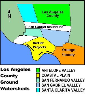
The natural ground water reservoirs beneath Los Angeles County consist of ground water basins which are grouped together under five major geographic areas. These areas are the Antelope Valley, Coastal Plain, San Fernando Valley, San Gabriel Valley, and Santa Clarita Valley. The basins within these locations are separated by natural geologic features which impede groundwater movement or by arbitrary political boundaries.

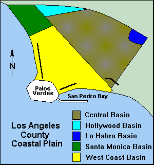
TheCoastal Plain of Los Angeles consists of five different basins: Central, Hollywood, La Habra, Santa Monica, and West Coast Basins. The Central and West Coast Basins are the two largest basins in the group. Two million residents of the Coastal Plain depend on groundwater that is protected by the barrier facilities for approximately 35 percent of their potable supply.

CENTRAL & WEST COAST BASINS
The Central Basin (CB) is bounded on the north-west by the Santa Monica Mountains, on the north-east by Merced and Puente Hills, and on the south-east by the Orange County Boundary. Imported water injected through the Alamitos Barrier project contributes to CB replenishment. The facility was primarily designed to protect the ground water supplies of this basin from intrusion through the Alamitos Gap area.
Similarly, the West Coast Basin (WCB) is bounded on the west and south by the Pacific Ocean, on the north by the Ballona Escarpment and on the east by the Newport - Inglewood Uplift. This fault forms a natural barrier to groundwater flows from the adjacent CB to the southerly WCB. Groundwater in this basin is primarily recharged from the two remaining barrier projects and from limited CB underflow. The Dominguez Gap Barrier facility was designed to prevent intrusion from San Pedro Bay, the West Coast Basin Barrier Project from the Pacific Ocean.
RECLAIMED WATER RECHARGE
Beginning in June of 1995, West Basin Municipal Water District began conveying highly treated recycled water to the West Coast Basin Barrier Project for recharge. The water is blended to a 50% ratio with imported water.